
Getting There
After one rest day which was also my travel day from Lagodekhi to Borjomi, I started a new trekking adventure. From Tbilisi you will need to take the metro to Didube Station. From there you will find a marshrutka parking lot and can ask a local where to find the van to Borjomi. I spent one night in Borjomi since it was technically my rest day. A lady offered me a guest house when I stepped out of the marshrutka. I agreed to it at the price of 25 Lari. After my hike I used bookings.com and found a guest house “Guest House Borjomi” for 15 Lari. This second guest house was a lot nicer and cheaper which goes against what typically happens when you book online. Both guest houses offered me coffee, sweets and cherries.
The next morning I walked to the information center and received an explanation on the trails. I was given a map and I paid 5 Lari a night to use my tent and a 5 Lari park fee. Technically, nobody checked my receipt once I entered the park so I suppose signing in at the visitors center isn’t necessary.
St. Andrew’s Trail-Day 1
The man at the office recommended that I do St. Andrew’s trail since I had four days to spend there. A bridge was blocked somewhere so instead of doing the full loop he was having me make it to the second night’s shelter on the highest peak of Borjomi and then return to the first night’s shelter for my third night. Even with his alternated route the trek was going to be 52 kilometers.
I had to hitchhike to the start of the trail which was 28 kilometers from Borjomi. I was left at a train track with no trail markers. I followed the map I was given which showed a spring I had to cross and based on that information I eventually found the trail. I ascended the mountain on a 16 kilometer trail.
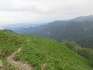
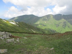
I saw bear tracks and thought back to something I read about keeping a bell on you so you don’t sneak up on a bear. I didn’t have a bell so I decided to occasionally sing and clap my hands. It was sporadically drizzling and I had my poncho on for most of the hike. After a few hours in the forest, I reached the tree line and was at what the map called the viewpoint. From the viewpoint there was an even steeper ascent broken up by intermittent flat stretches.
I was hiking up a steep mountain with no trees over head when it suddenly started to rain (so I thought). Then something whacked my hand and I realized it was hail. I had to run up the hill and rush for the tree cover. I hid under a tree branch and curled up into a duck and cover position. As I looked out to the trail I saw the grass get covered in white as tiny ice balls fell down. Five minutes later it stopped and I continued on.
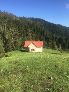
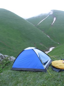
Eventually I saw the rest house in the distance and had to descend into a valley. Even though I brought my tent, I decided to stay in the rest house after that shocking encounter with hail. The tourist shelter was in a scenic valley. Behind the hut was a steep cliff with a swirly rock face. This cliff is what I would have to ascend the next day.
St. Andrew’s Trail-Day 2
The hike to Sametskhvario shelter the next day was an absolute disaster. The trail was hardly marked and it was impossible to hike with confidence. Ascending from the tourist shelter, there were no markers at all. I followed tire tracks assuming they must lead to the shelter from when they built it. Eventually I reached an area where tracks couldn’t go and made a guess as to which way to continue. Half an hour after that guess I saw a trail marker confirming that I was on the right path. The safest bet to finding my way was to follow the indentations in the grass.
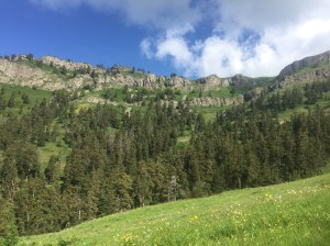
The paper map showed that when you see a shepherd’s hut you continue straight. However, when you see a second shepherds hut you turn right. Keeping that in mind I eventually found the hut and continued straight. There were no trail markers and everything looked like a trail because the shepherds lead their cattle through these fields.
Trying to follow the shape of the trail on the paper map I continued on, getting more and more confused by the second. On the mountain ahead of me I saw a hut and thought I was at the tourist shelter! I couldn’t see a way to get to it though and I thought I had reached a dead end. As I approached the cliff side I found a small trail leading downward. I was in a tiny valley before ascending the mountain with the hut.
As I approached the hut I saw many cows grazing on a hill. As I got closer a dog appeared and started barking at me. He then charged at me and I had to run back the way I came. I waited for the shepherd to appear but eventually gave up and turned around. I knew I wouldn’t reach the tourist shelter and decided to camp in the valley between the two mountains. Good thing I brought my tent!
The hike to the second shelter was supposed to be ten kilometers and take only five hours. I had been hiking for eight hours and never made it. Something seemed off.
I was nervous about camping in the valley. Would I be too cold? Would it rain or hail? Would a shepherd mess with me? The night was perfect by some miracle; I had been cold in the rest shelter the night before but somehow slept soundly that night in my tent.
St. Andrew’s Trail-Day 3
The next morning I retraced my steps to return to the night one rest shelter. After passing the hut that guided me to go straight I continued on. To my surprise as I was descending the mountain I saw a hidden hut. That must have been the hut I was supposed to go straight at and the hut I went straight at was the one I needed to turn right at. It turns out I was on the wrong mountain completely! The trail was so infrequently marked and the hut they used as a physical cue was only visible on the return journey. Disgruntled about trails with bad trail markers I went back to the original shelter.
St. Andrew’s Trail-Day 4
On the fourth day I was supposed to take an alternative 18 kilometer path bath to the highway. But what do you know I couldn’t find the trail markers for it. I ended up taking the 16 kilometer path I took to get there. There was a bit when the trail was on the road and I absentmindedly ended up following the road and lost the trail. Not wanting to backtrack I turned on my phone and decided to navigate to the highway. I found trails that lead me to a creek. I followed the river and eventually ended up in the backyard of farms. Eventually I popped out in the tiny town of Atskuri. I hitchhiked back to Borjomi and stayed at the guest house I found online. I took a much needed showered and then went to Old Borjomi restaurant to treat myself to khinkali and a pitcher of wine.
St. Andrew’s trail was very frustrating with its lack of trail marks. However, the views were stunning and I met many cool trekkers along the way. I had originally wanted to hike from Mestia to Ushguli in the Svaneti but went to Borjomi instead because it was supposed to rain everyday in the Svaneti region. Borjomi is farther South and was supposed to have better weather. If you can come to Georgia in July or August you should save yourself the frustration of St. Andrews and try a different park.
